By Abu, I. Michael
The acting Surveyor General of the Federation (SGOF) Surveyor Taiwo S. Adeniran has appealed to Government at all levels and political leaders to prioritize surveying and mapping and accord it a place of pride in the scheme of affairs in order to accelerate socioeconomic growth and development in the country.
Surveyor Adeniran said surveying and mapping could aid economic recovery efforts of the Government; facilitate the creation and improvement of greater opportunities for Internally Generated Revenue.
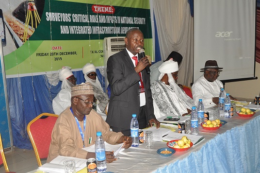
The acting SGOF who was speaking at the inaugural Conference of Surveyors General of Nigeria (COSGON) and Management Staff of OSGOF at Lafia, Nasarawa State reiterated the critical and fundamental role of surveying and mapping to infrastructural development, military operations, community policing and security management, agriculture, industrial and technological advancement of all sectors of the economy.
He asserted that countries that were most developed were those that give much attention to surveying and mapping pointing out that the United Nations Global Geospatial information Management has since tied the achievement of the 17 Sustainable Development Goals (SDGs) to the operationalization of Integrated Geospatial information Framework (IGIF). He explained that the IGIF has to do with the integration of all other information to geospatial data to create Evidence-based Decision Support System noting that it was the global next level agenda for National Spatial Data Infrastructure (NSDI) which has gone further to encouraged countries to design their Action Plan for establishment of the framework. He disclosed that OSGOF has developed the Country-Level Action Plan for Nigeria’s IGIF, and “it has been presented recently at the AfricanGIS Conference in Kigali, Rwanda”, he said.
The Surveyors Conference, he says, “Provides a huge opportunity for the Surveyors General of all states of the federation and the management staff of OSGOF to ventilate on how best to ensure the nationwide buy-in and utilization of Geospatial Information especially in our infrastructural plans and development. It will afford the exchange of ideas, information and experience-sharing that would help the promotion of best practices in surveying and mapping in the country”.
He called on all the Surveyors General in the country to align their activities with the Next-Level Agenda 9 priority agenda of the Federal Government for achievement of the laudable projects of the Government, which he said would remain a mirage if surveying and mapping were neglected.
Adeniran expressed appreciation to the Federal government for providing financial support to ensure the inauguration of the conference in Lafia, as he congratulated the Government and good people of the state for being the first to host the COSGON.
President of the National Institution of Surveyors (NIS), Surveyor Alabo C. D. Charles and Chairman of Northern Surveyors Forum who is the former Registrar of Surveyors Council of Nigeria (SURCON), Surveyor Winston Ayeni in their goodwill message said the conference was apt. They reemphasized the importance of surveying and mapping to effective planning and even development calling on Government to take seriously surveying and mapping to ensure durable achievement. They asserted that surveying and mapping could generate enough funds for the Government.
In his address of welcome, the Director Special Duties Surveys, Surveyor Ajingi Muhammad Ahmad mentioned that the COSGON and management staff of OSGOF was crucial because it offered a common platform for useful interactions among critical stakeholders from every part of the country in ways that would inform better policy formulation and implementation.
Surveyor Ahmad said his department would continue to explore other avenues to evolve forums for regular interactions between OSGOF, all Surveyors General in Nigeria and other professionals. He said such interactions would enable cross fertilization of ideas that would help provide the country a guide for rapid socioeconomic development.
He said his department coordinates 6 zonal directors for all the zones in the country and 36 Chief Resident Surveyors for the states. He urged the Surveyors General to carry them along in all their activities to enhance better operations of surveying and mapping to generate reliable geospatial information needs of their respective states.
Commissioner for Lands and Urban Development, Nasarawa State, Professor Salihu A. A. Aligaza was full of praise for the choice of Lafia for the conference. He said the state government under Governor Abdullahi Sule was committed to making Nasarawa State a model, and would as such continue to support activities of Surveyors, because the state was aware of the role of surveying in nation building.
The Emir of Nasarawa, His Royal Highness, Alhaji Ibrahim Usman Jibrin, a former Minister of Environment made a power-point presentation on “The role of traditional rulers in boundary delineation.” Surveyor Barde Jatau lectured on “Unification and modernization of Geodetic Reference frame in Nigeria”, while Surveyor Mooshood Onifade Akinwande took the conference participants on the “Standard and establishment of Continuously Operating Reference Station (CORS) in Nigeria”.


