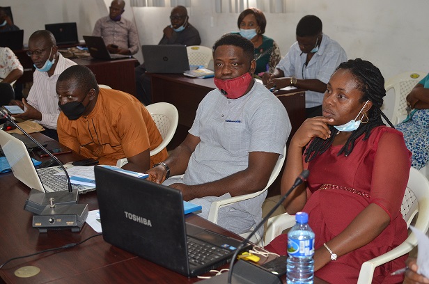
The Office of the Surveyor General of the Federation (OSGoF) has commenced a 5-day training on Digital Cartography with a pledge by the Surveyor General of the Federation (SGoF), Surv. Samuel Adeniran Taiwo to ensure upgrade of surveyors and other staffers of the Office for optimal performance that would help to boost effective planning and national development.
Cartography is the art and science of making maps; a map which is “a diagrammatic representation of an area of land of sea showing physical features, cities, roads, etc” is a necessary instrument of analyzing, planning, and implementation to ensure success and good governance generally.
Surv. Taiwo who gave the pledge during his remarks to declare open the training at the Office’s conference room in Abuja said Nigeria desired the best of surveyors because of the dynamic interplay of geographic elements.
He said ignorance remained a major problem that stagnate growth and development and as such, his leadership would be conducting various trainings for the staff of OSGoF from time-to-time even with the scarcity of funds.
He maintained that the value of people is determined by the quantum of knowledge deposited in them and that the building of the capacity of a worker could not be overemphasized.
The SGoF disclosed that he was already in consultation to reactivate some other international trainings supported by Indian and Korean authorities.
Areas to be covered during the training both theoretically and practically include Introduction to Digital Mapping; Cartographic Design; Topographic and Thematic Mapping; Web cartography and Multimedia; Mini Cartographic Project; Data Acquisition Techniques and Sources; and Introduction to Arc Map. Others were Topographic and Thematic Mapping Specifications; Cartographic Design: Map Content, Design, and Implementation; Introduction to QGIS; and Project Presentation.
The training was being conducted by a team of resource persons led by Surv. Ayila Adzandeh and Mr. Paul Borisade from the African Regional Institute for Geospatial Information, Science and Technology (AFRIGIST) at Obafemi Awolowo University (OAU), Osun.
Last week, the Office organized a training programme on Nigeria’s Land and Maritime Boundary Demarcation and Management conducted by Afri Boundary Experts Nig. Ltd.
Signed:
Abu, I. Michael
Head of Press and Public Relations


