The Office of the Surveyor General of the Federation (OSGoF) is collaborating with the Independent National Electoral Commission (INEC) and the National Population Commission (NPC) towards updating Nigeria’s provisional administrative map.
The map is expected to help identify administrative boundaries such as interstate, local government and ward boundaries in the 774 local government areas that constitute the 36 states of the country including the FCT, Abuja.
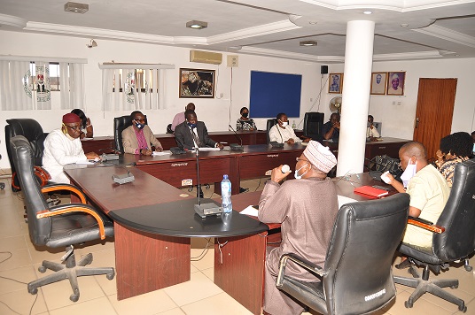
Director of Photogrammetry and Remote-Sensing, Surv. Okafor Sylvester Obiagulu who chaired the inaugural meeting of the technical committee on behalf of the Surveyor General of the Federation (SGoF), Surv. Taiwo S. Adeniran commended INEC and NPC for their appreciation of the services and products of OSGoF. Such synergy would be for the greater benefit of the Nigerian Government and all sectors of the economy, he explained.
The effort is to provide administrative map with requisite geospatial data/information that would be useful for delineation of wards in their appropriate local government areas, polling zones for purposes of elections and enumeration areas for successful conduct of population census.
Members of the committee in their discussions pledged to ensure the provision of a map that would also be used by the government and policy formulators and implementers for effective sociopolitical and economic planning, evidence-based decisions that would bring about proficiency in governance generally.
The committee noted the importance of working in tandem with the National Boundary Commission (NBC) and expanding the committee to accommodate other critical stakeholders in its subsequent meetings.
Ahead of the INEC team at the meeting was the Deputy Director, Electoral Operations in charge of Delimitation of Constituencies, Yakubu Duku with the Director of Cartography, Ogunsina Joseph leading the NPC team.
Signed:
Abu, I. Michael
Head of Press and Public Relations


